The Elbrus Expedition 2016 kicked off the challenge to climb the world’s highest mountain on each continent. I will attempt to climb all the 7 summits within the next 5 years as part of this amazing challenge.
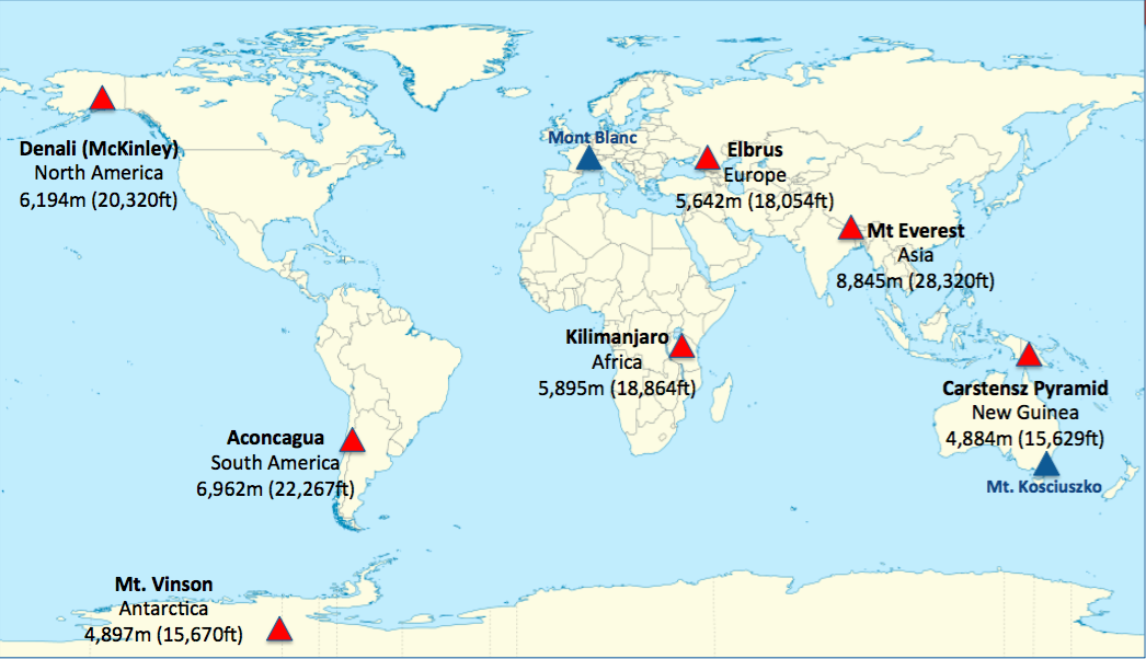
The Seven Summits are the highest mountains of each of the seven continents. Summiting all of them is regarded as a mountaineering challenge, first achieved on April 30, 1985 by Richard Bass.
As just over 300 people have reached the Seven Summits it remains an elusive, though obtainable goal. From a technical standpoint each climb offers its own, unique challenges.
ANTARCTICA’S HIGHEST SUMMIT
ALTITUDE:         4,892m (16,050 ft)
DIFFICULTY RATE:  Technical 3
                  Physical  3
SUMMIT GPS POINT: S 78 31.088
                  W 85 37.585
ELEVATION GAIN:   (Base camp to Summit)
                  Normal route: 2,792m
DISTANCE:         (Base camp to Summit)
                  Normal route: 19 Km
DURATION:         16 days
SEASON:           November - December - January
Antarctica is truly the last frontier. This continent, a mass of rock and ice covering 14 million Sq Km of area, including the South Pole, is larger than Europe. Antarctica has no government, no permanent population, is not ruled by any country, and is the only continent without and indigenous population. The landmass is controlled under the Antarctic Treat, signed in 1959 and in force as 1962. Antarctica is the coldest continent on Earth.
SOUTH AMERICA’S HIGHEST SUMMIT
ALTITUDE:         6,962m (22,841 ft)
DIFFICULTY RATE:  Technical 2
                  Physical  3-4
SUMMIT GPS POINT: S 32 39.13
                  W 70 00.45
ELEVATION GAIN:   (Base camp to Summit)
                  Normal route: 2,692m + trekking
DISTANCE:         (Base camp to Summit)
                  Normal route: 12 Km
DURATION:         21 days
SEASON:           December - January - February
Aconcagua is the tallest mountain in the Western Hemisphere. It sits entirely within Argentina just east of the border with Chile, some 150 Km east of the Pacific Ocean. At 6,692m, the “Stone Centinel” (Centinela de Piedra) towers above all other mountains in the Andes Range.
AFRICA’S HIGHEST SUMMIT
ALTITUDE:         5,895m (19,340 ft)
DIFFICULTY RATE:  Technical 1-2
                  Physical  2-3
SUMMIT GPS POINT: S 03 04.585
                  E 37 21.240
ELEVATION GAIN:   (Base camp to Summit)
                  Machame route: 4,085m
DISTANCE:         (Base camp to Summit)
                  Machame route: 45 Km
DURATION:         16 days
SEASON:           January - February - March & June to mid October
The tallest mountain on the continent of Africa, Mount Kilimanjaro sits 322 Km south of the equator in Tanzania, a country located approximately half way up the eastern seabord of Africa. Kilimanjaro’s summit rises more than 5,100m out of the arid plains below, just a short distance south of the border with Kenya.
AUSTRALASIA’S HIGHEST SUMMIT
ALTITUDE:         4,884m (16,024 ft)
DIFFICULTY RATE:  Technical 5
                  Physical  3
SUMMIT GPS POINT: S 4 04.733
                  E 137 09.572
ELEVATION GAIN:   (Base camp to Summit)
                  Normal route: 952m
DISTANCE:         (Base camp to Summit)
                  Normal route: 2 Km
DURATION:         21 days
SEASON:           All year around
Carstensz Pyramid is the highest mountain in Australia and Oceania and is situated in west Papua (now named Papua province Indonesia).
The wall of the Carstensz Pyramid is about 500 – 600 meters (1640 – 1968 ft) high. In the upper part it is traversed by a gigantic ledge, in which to big culoars went. The bottom part of the wall – approx. 300 m (984 ft) is „neatly“ bowed at an angle of 10 – 15°. The upper part of the wall is approx. 80 m (262 ft), and it is almost vertical. The peak crista of Carstensz Pyramid is largely rugged and exposed. Some climbers say that the wall of Carstensz Pyramid is as sharp as glass, and they are not far from the truth.
ASIA’S HIGHEST SUMMIT
ALTITUDE:         8,850m (29,095 ft)
DIFFICULTY RATE:  Technical 4
                  Physical  5
SUMMIT GPS POINT: N 27 59.28677
                  E 86 55.51464
ELEVATION GAIN:   (Base camp to Summit)
                  South Ridge route: 3,523m
                  Northeast Ridge route: 3,489m
DISTANCE:         (Base camp to Summit)
                  South Ridge route: 20 Km
                  Northeast Ridge route: 36.5 Km
DURATION:         58 days
SEASON:           April - May - June & September - October
Mount Everest is one of the most iconic symbols in the world. Whether you are a climber or not, you will undoubtedly have heard of Mount Everest and the climbing lore and reputation that goes with it. Everest has pervaded popular culture, and the recent climbing boom has made Everest a household name.
NORTH AMERICA’S HIGHEST SUMMIT
ALTITUDE:         6,194m (20,320 ft)
DIFFICULTY RATE:  Technical 3
                  Physical  5
SUMMIT GPS POINT: N 63 06.9526
                  W 151 01.5472
ELEVATION GAIN:   (Base camp to Summit)
                  Normal route: 3,877m
DISTANCE:         (Base camp to Summit)
                  Normal route: 29 Km
DURATION:         31 days
SEASON:           May - June - July
Lying in the heart of the 960 Km long Alaska Range, Mount McKinley or Denali, is the largest mountain in North America, rising 6,194m above sea level. Denali towers almost 5,500m above the surrounding tundra, giving it more vertical rise than Mount Everest.
EUROPE’S HIGHEST SUMMIT
ALTITUDE:         5,642m (18,510 ft)
DIFFICULTY RATE:  Technical 2
                  Physical  2-3
SUMMIT GPS POINT: N 43 21.129
                  E 42 26.010
ELEVATION GAIN:   (Base camp to West Summit)
                  Normal route: 1,742m
DISTANCE:         (Base camp to Summit)
                  Normal route: 9 Km
DURATION:         15 days
SEASON:           June - July - August
Mount Elbrus, the highest summit of Europe, rises 5,642m above sea level in the Caucasus Mountains, a range 1,125Km in lenght, sandwiched between the Caspian and Black Seas. To the North of the Caucasus lies forest and steppe; to the south a drier desertlike environment. The Caucasus Range includes the fourteen highest mountains in Europe. Mount Elbrus is tucked deep within the Caucasus Range in the southwestern corner of Russia, close to its border with Georgia. It has two prominent summits: the east (5,621m) and the west (5,642m).